Topographic Maps Lab
Topographic maps are an important source of information for land management, planning, agriculture, backpacking and hiking, and geographical research. In the United States, topographic maps are produced by the U. S. Geological Survey (USGS). These maps can be ordered by mail from the U.S.G.S., and they are sold at some government offices and at many retail camping stores and book stores across the country. The SSU Dept. of Geography Map Library has a (nearly) complete collection of topographic maps of California and selected maps from all over the U.S. and other parts of the world.
Use ONLY PENCILS while working with maps, so that no permanent marks are accidentally made.
Many types of information are shown on topographic maps, including cultural features -- roads, settlements, transportation systems, industrial buildings, public lands, political boundaries -- and natural features -- shape of the land surface, rivers, lakes, swamps, beaches, glaciers, vegetation. In this exercise, we will focus on learning to read the environmental information contained on U.S.G.S. topo maps.
In Geography 360, we will use the metric system of measurement as much as possible, but the English system will also be used because USGS maps use it.
7.5' QUAD MAP OF SANTA ROSA, CALIFORNIA
The north arrow printed on the lower margin of each map indicates how the map is oriented. Find the north arrow on the lower margin of the map. Three different "norths" are shown. True north (geographic north), shown by the line pointing toward a star, is toward the top of the map sheet. A line running true north will eventually run into the North Pole (90o N. lat.). The left and right edges of the printed map are true north-south lines. The line labeled MN (magnetic north) points toward the magnetic north pole, which slowly moves around on the earth's surface. The magnetic north pole is currently located in northern Canada, about 1500 km from the geographic North Pole. A compass needle will point toward the magnetic north pole. Therefore, if you were using this map and a compass to walk a straight line between two points in the vicinity of Santa Rosa, it would be important for you to know that the compass needle points 17o east of true north (at the time this map was published). The difference between true north and magnetic north, called the magnetic declination, will not affect our use of the map in this exercise. The third north arrow (shown as a line pointing toward GN) shows the direction of grid north for the UTM location grid (Universal Transverse Mercator grid) printed on the map. This is a location system that uses meters instead of degrees of longitude and latitude. We will not be concerned with grid north.
In this exercise and future exercises, directions will be described, or you will be asked to give directions, usually in terms of "cardinal", or "compass" direction. By this we mean geographic north, northeast, east, southeast, south, southwest, west, or northwest. In some cases more specific directions such as north-northwest or east-southeast will be used. These directions can be estimated visually by reference to north-south and east-west lines such as the edges of the map. (In more precise applications, directions and bearings are measured by placing a compass on the map and reading to the nearest degree, then correcting the magnetic bearing to the geographical bearing by adding [or subtracting] the declination. We will be learning about this during our field trips).
The scale of each map is shown in several different ways in the lower margin. On this map, the scale is expressed as a ratio, 1:24,000. That is, one inch on the map equals 24,000 inches on the land surface, or one centimeter on the map equals 24,000 centimeters on the land surface.
How many feet on the land surface does one inch on the map represent?
How many kilometers on the land surface do four centimeters on the map represent? (Show your work-- no credit given without this)
The scale of the map is also shown by graphic scales in miles, feet, and kilometers. The graphic scale can be used to make a ruler for measuring distance on the map in miles or kilometers, by marking miles or kilometers along the edge of a sheet of paper. Using a paper ruler, measure the dimensions of the Sonoma County Fairgrounds just southwest of the center of the map, and estimate its area in both square feet and square meters (1 km = 1000 m).
_____________ square feet_____________ square meters
Color coding on the map makes it easier to read. All USGS topo maps use the same color system.
|
brown: contour lines |
red: major roads, also section lines and land boundaries |
|
|
blue: water features |
purple: recent revisions |
|
|
green: woodland |
pink or gray: urban areas |
|
|
black: cultural features |
Some of these colors have changed on the newer USGS maps. A key to symbols for USGS topo maps may be found at the Department's Geographica web page and hardcopy versions are available from Professor Freidel. You should become familiar with most of the symbols.
LOCATIONS ON EARTH
In the study of the earth's environment, it is necessary to have a system for locating places on the earth's surface. The most widely used method of specifying location is the geographic coordinate system of latitude and longitude. The parallels of latitude and meridians of longitude are shown on Figure 1-1.
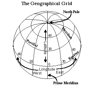
Latitude specifies how far north or south of the equator a point is located. Latitude is given in degrees of arc from the equator (0o latitude) to the geographic North Pole (90o N. lat.) or to the geographic South Pole (90o S. lat.). For example, a place located exactly halfway between the equator and the South Pole is at 45o S. lat.
Longitude indicates how far east or west of the prime meridian a place is located. The prime meridian is a line running true north-south, from the North Pole to the South Pole, through Greenwich, England (a suburb of London where the British Royal Naval Observatory is located). The prime meridian is the 0o longitude line. The meridian exactly opposite the prime meridian, on the opposite side of the earth, is the 180o longitude line. The International Date Line runs along the 180o meridian, with some jogs. Longitude is measured in degrees east or west of the prime meridian, running from 0o to 180o west longitude and from 0o to 180o east longitude.
For more detailed measurement of location, each degree of latitude and longitude is divided into sixty minutes (symbol is ') and each minute is divided into sixty seconds (symbol is "). On the U.S.G.S. topo maps, latitude and longitude are shown in black ink in the margin at each corner of the rectangle.
What is the location of the upper right corner of the Santa Rosa map?
Latitude:__________________Longitude:_________________
By convention, the location of a place is stated with latitude first, then longitude, for example 43o30'N, 122o52'30"W. It is important to include North or South, East or West.
Note that the upper right corner of the Santa Rosa map is 7'30" of longitude east of the upper left corner. Find the black tick marks for 40' and 42' 30" on the top margin. The length of the line along the top margin represents 7'30" of longitude. The north-south lines along the left and right sides of the map each represent a distance of 7'30" of latitude. (Tick marks for intermediate latitudes are also shown on the margins.) Therefore, the area mapped is 7.5' latitude by 7.5' longitude, and the map is called a 7.5' quadrangle.
Find St. Eugene School near the center of the map. What is its location, to the nearest minute? Find the latitude tick marks for 38o25'00"N and 38o27'30"N latitude on the right margin of the map; find the same tick marks on the left margin. You can see the position of the 38o27'30"N latitude parallel by holding a long ruler or straight edge of paper between the tick marks on the right and left sides. You must determine which latitude minute line St. Eugene School is nearest. To determine which minute of latitude is closest to St. Eugene School, you will need to find the positions of 38o26'N and 38o27'N. Measure and subdivide the distance (into five 30" intervals) between 38o25'00" and 38o27'30"N, and make a paper ruler showing the positions of 38o26' and 38o27'N latitude. Project these lines across the map to see which minute of latitude St. Eugene School is nearest. (Please do not draw on the map.)
On the top and bottom margins you will find tick marks for 122o40'30" and 122o42'30" longitude. Locate and project the 122o41' and 122o42' longitude lines as you did for the latitude lines, and determine which longitude minute line is closest to St. Eugene School.
St. Eugene School:
latitude:__________________longitude:_________________
Two other systems of locating places on the earth are shown on this map, the UTM grid and the Public Land Survey System (also known as the Township and Range system). The Public Land Survey system, widely used in the central and western U.S., is shown on U.S.G.S. maps by red solid and dashed lines, red section numbers, and red labels for township numbers along the vertical margins of the map and range number along the horizontal margins of the map. This system will be used in several of our exercises. Read the short explanation of the Public Land Survey System from Bryan Baker's Map Interpretation.
The UTM system is shown by black numbers and thin blue tick marks along the margins of the map. However, we will not use this system in Geog. 360. I'll be happy to explain this system if you're curious.
CONTOUR LINES
A contour line is a line on a map which joins together points which have the same elevation. Elevation of the land surface is measured in feet or meters above a datum, such as sea level. On U.S.G.S. topo maps, the datum is mean sea level, so all elevations are in feet above sea level. Contour interval is the change in elevation moving from one contour line to the next. The contour interval of a map can be set at any convenient elevation spacing -- 1, 10, 20, 50, 100, or 1000 feet. In general, a large contour interval is used when the terrain is steep and rugged, and a small contour interval is used when the terrain is relatively flat.
What is the contour interval on the Santa Rosa map?
Look at the contour lines representing Taylor Mountain, in the southeast quarter of the map. Note that every fifth line is a heavier brown line, called an index contour line. On this map, the index contour lines are at, for example, 800 ft., 900 ft., 1000 ft., etc., above sea level. Intermediate contours are usually not labeled, so you must determine their elevation by counting up or down from the nearest labeled contour line. In flatter areas, such as the flood plains of the rivers, supplementary contour lines are often added for every five or ten feet of change in elevation, as specified on the map legend. Supplementary contours are shown by thin dashed brown lines.
There are five general rules regarding contour lines which will help you to understand the shape of the land surface.
1. Contour lines do not cross each other and they do not branch.
2. Each contour line is continuous and closes on itself unless interrupted by the edge of the map.
Find the hill just south of Weeks Creek and North of Ducker Creek in the northeast corner of the map, labeled 1,432' (NE1/4, Section 4, T7N, R7W). Find the 1100 foot contour line. Follow this line. Does it close on itself or is it interrupted by the edge of the map?
Find the 1400 foot contour line. Does it close on itself or is it interrupted by the edge of the map?
3. Contour lines enclose higher ground. There are many groups of crenulated contour lines on these maps that indicate hills dissected by small drainages. For instance, find Cooks Peak in the south-central portion of the map (SW 1/4, Sec 6, T6N, R7W). Note that the elevation of the land increases as you move toward the center of this group of concentric circles. The area within the smallest circle is the peak of the hill.
In the case of depressions, such as sink holes or pits, contours enclose lower ground. In these cases, a special symbol is used -- a contour line with short spikes or tick marks which point into the depression. One example is just northwest of Bellevue Union School in the NW 1/4 of Sec. 3, T6N, R8W, in the southwest corner of the map. The 100 foot contour line encloses a depression here. The spikes on the contour line indicates that the land within each enclosed contour is below the elevation marked by the contour line.
4. Spacing of contour lines indicates the relative steepness of the land surface. Closely spaced contour lines indicate a steep slope; widely spaced contour lines indicate a gentle or flat slope.
In the southeast part of the map, look at the contour lines on either side Taylor Mountain peak (1401 feet, N 1/2 of Sec 6, T6N, R7W). On which side of Taylor Mountain peak is the slope steeper, the northeast side or the southwest side?
In what compass direction is the more gentle slope facing?
The direction in which a slope faces is called the aspect of the slope. Aspect is a very important factor in local soils, vegetation and geomorphology. In the Northern Hemisphere, south-facing slopes receive more intense sunlight than north-facing slopes because the south-facing slope is oriented toward the incoming rays of sunlight. Therefore, south-facing slopes are in sunlight most of the day, and north-facing slopes may be in shadow most of the day. Soils are generally warmer and drier on south-facing and west-facing slopes than on north-facing slopes. As a result, the vegetation cover may be grassland on south-facing slopes and forest on north-facing slopes.
5. Contour lines indicate the direction of flow of rivers and streams. Contour lines are V-shaped where they cross streams. The point of the V points in the upstream direction (upslope).
In the south-central part of the map, locate the creek that flows just north of Cooks Peak, beginning in the W1/2 Sec 6, T6N, R7W. In what compass direction is this creek flowing?
The solid blue lines indicate year-round creeks, while the alternating lines and dots are intermittently flowing streams. In many places you will see a group of nested, V-shaped contours, with no blue line for a stream. In these cases, there may be no visible stream channel on the land surface at this spot. However, water probably does collect here to flow in a stream-like fashion during rainstorms.
CONSTRUCTING A CONTOUR MAP
Figure 1-2 is a map showing raw data which can be used to construct a topographic map. Each dot represents a point on the land surface, and the elevation of the point, in feet above sea level, is written beside it. The heavy black lines represent streams. The 1000 foot contour lines have been drawn in lightly. Note that they intersect all points at 1000 feet, and separate points which are higher than 1000 feet from those lower than 1000 feet.
Complete the topographic map, starting with the 950 foot contour line. Make the contour interval 50 feet. Use a pencil. Start with the 950 foot point near the upper right edge, and extend the contour line across to the left, crossing the two streams, then up to the top edge of the figure. The 950 foot contour line is interrupted by the edge of the map in several places. Draw in the 950 foot contour line by visually estimating the spacing between adjacent dots that are higher and lower than 950 feet. Should the 950 foot contour be drawn closer to the 911 foot point or to the 971 foot point? Begin again on the right edge of the map at the bottom, crossing the two streams drawing your line to the left between the 912 foot point and the 979 foot point, etc. When you finish the 950 foot lines, label them at several places, along the contour line or outside the margin of the map. Then complete the map by drawing in contour lines at 850, 900, 1050, etc. feet. Draw in all of the contour lines appropriate for this map. When you are finished drawing all of the lines, check to make sure that they all look correct. If your lines run straight across the rivers, erase each contour line and draw it in as a "v" pointing upstream. Make sure that you include all appropriate contour lines and that they follow all the rules outlined above. There are several correct solutions to this puzzle.

TOPOGRAPHIC RELIEF
Relief is the difference in elevation between the highest spot and the lowest spot in the landscape. The term local relief refers to relief within a small area, such as a single hill or a watershed. What is the local relief at Cooks Peak, from the top of the hill downslope to the southwest to Petaluma Hill Road?
The term regional relief refers to relief over a larger area. Find the highest point on the Santa Rosa map. What is its elevation, and location?
Find the lowest point on the Santa Rosa map. What is its elevation and location?
What is the regional relief on this map?
Contours also show the steepness of streams and rivers. In the south-east part of the map, locate the creek that flows east, beginning southeast of Taylor Mountain (NE 1/4 Sec 6, T6N, R7W). Find its highest point. What is the elevation of its highest point? It's lowest point?
How many contour lines cross the creek before it reaches the reservoir on Matanzas Creek?
What is the fall, or change in elevation, of this creek as it flows across the area shown on the map?
A quantitative estimate of gradient (steepness of a slope) can be made using a topographic map. Gradient of a slope indicates the change in elevation over a specified horizontal distance. It is most conveniently expressed as a percentage or a decimal, but it may also be expressed as a ratio, a fraction, or an angle in degrees. Gradient is measured along a straight line running perpendicular to the contour lines.
Find Section 1, T7N, R8W. Look at the slope that rises from the creek bed that is just west of the red numeral 1 (section number) east upslope to a gentle upland at about the 760' contour line. Along this slope the contours are quite evenly spaced, indicating a single straight slope rather than a slope which varies in steepness.
Determine the gradient of this slope between the 460 foot contour line and the 760 foot contour in the following way:
1. What is the change in elevation, in feet, between these two contour lines?
2. What is the horizontal distance, in feet, between these two points? (Hint: recall that the scale of the map is 1:24,000, thus one inch on the map equals 24,000 inches on the ground.)
3. What is the gradient, expressed as a decimal (vertical distance divided by horizontal distance, or "rise" over "run)?
4. What is the gradient expressed as a percentage (multiply the decimal by 100)?
5. The gradient expressed as a decimal is a tangent, and the angle of the slope can be determined by finding the angle (in degrees) which corresponds to this tangent (using a trig table or a calculator with trig functions). Using the trigonometric table or your calculator, what is the angle of this slope?
6. What is the aspect of this slope?
Acknowledgements
Dolly Friedel has graciously shared many of the materials you see here.Copyright D.E. Freidel, 2008. Portions of this lab were adapted from P.F. McDowell's Geomorphology Exercise 1, 1990. No portion of this material may be copied without written permission of the author.