Intro to Iceberg Science
October 2003 to December 2003
Because of the potential for sea level rise, scientists have an interest in what large
ice sheets will do under changing climate conditions. Ice sheets are complex
systems. Large portions of the Antarctic ice sheet drain into ice shelves.
The flow characteristics of these ice shelves help to determine the rate at
which ice from the continent (that which can affect sea level) flows to the
sea. The glaciers that flow into the Larsen A and B ice shelves have sped up
now that the ice shelves have disintegrated and the restraining force they
once provided is no longer there. Ice shelves are simpler systems than ice
sheets, because the basal boundary conditions are known. The basal temperature
is constrained to be about the melting temperature of ice at that pressure and
there is negligible basal friction. This contrasts with the ice sheet situation
where the basal temperature can be affected by geothermal heat and the basal
friction is highly variable depending on the nature of the bedrock or sediment,
the water content in the sediment, and a number of other things. Ice shelves
lose mass either through melting or calving of icebergs. In Antarctica, the
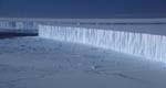
icebergs that calve off the ice shelves around the continent can be quite large
(300 by 40 km in the case of B15). These icebergs present an even simpler case
than ice shelves for studying the flow of ice under natural conditions. In
addition to the known basal boundary conditions, we also now know that there
is negligible friction along all sides of the ice mass. This is the simplest
situation that exists for studying the flow of large masses of ice and it makes
modeling the flow quite simple in comparison with ice shelves and ice sheets.
The basic idea is that floating ice will spread out horizontally under the
influence of gravity - kind of like a slow version of pouring syrup on a
pancake, initially the ice will have a certain thickness and radius and at
some later time it will be thinner and have a larger radius. When I first
came to Berkeley, I worked to investigate this
creep on iceberg B15a in the Ross Sea, Antarctica through measurements of
the spreading rate of the iceberg and through modeling of the flow. It turned
out that the measurement we were trying to do was not as accurate as we had
hoped, so this portion of the project panned out and I began working on other things.
Fortunately, the iceberg project had many other aspects to it. At the most basic level, we wanted to track where the icebergs were going. For this we needed to put a GPS and a satellite transmitter on an iceberg. Then we wanted to figure out why the icebergs were going where they were going. For this we needed to put a weather station on the iceberg too. See a picture of the guts of one of our weather stations here. We now have stations similar to that one on three icebergs: B15a, B15j, and C16. Excerpted from the picture's caption: There are three main factors that affect the motion of icebergs. The first is the wind pushing directly on the iceberg. Hence we measure the wind with our weather station. The second is ocean currents pushing directly on the iceberg (and of course the ocean currents are largely driven by the wind). The logistics of putting a current meter on or under an iceberg of this size would be horrendously difficult, so we didn't do that. The third factor is subtle tilts in the sea surface caused by the tides and by storms with high winds. The tilt is the strongest factor for icebergs of this size, moving the icebergs in a roughly 1 km long ellipse each day. However, the tides produce no net motion unless another object (like the ocean bottom, an island, or another iceberg) gets in the way. Hence, the winds and currents may be more important for total net motion. We deployed a tiltmeter on C16 for a few months in the 2001-2 season but since the iceberg was grounded for that period we weren't able to measure the sea surface tilts that produce motion.
Another thing we are interested in is the seismic noises coming from the icebergs. The noises are created by iceberg-iceberg collisions, iceberg-ocean bottom/island collisions, cracking of the icebergs, and fluid (air or water) motion in passageways (i.e. old crevasses) in the ice. Some of these noises, probably iceberg-iceberg collisions are "heard" by seismometers as far away as Tahiti because the seismic wave propogates through the ocean with very little signal attenuation. Seismometers on Mount Erebus have picked up strange harmonic noises that may emanate from fluid motions within the icebergs. To get a better handle on where these noises are coming from and define the mechanism of noise creation, we set up 5 seismometers on C16 this season. Unfortunately, due to changes in the field plan that occured after the seismometer equipment had been allocated to us, some of the equipment couldn't handle the extreme cold of the early season. So we didn't get as much data as we had hoped. After a mid-season visit to the stations to restart them, they collected good data. At the end of the season that data was collected and some of the seismometers were retrieved. One was left in the field to collect data over the winter, both for the data relavent to the icebergs and as an engineering test to see if the new equipment can last an Antarctic winter.
A further reason to study these large icebergs is because they can serve as a test bed for climate change. The question we are interested in is: what will happen to Antarctica as the climate warms? The answer to the question is relevant to the general public as described above. One important piece of that question is: what will happen to Antarctic ice shelves as the climate warms? One way to answer the second question is to wait and see. Some of the ice shelves on the Antarctic Peninsula have already disintegrated but since they were small ice shelves to begin with, what happens there won't necessarily be similar to what happens to the large Antarctic ice shelves farther south (the Ross, Filchner-Ronne, and Amery Ice Shelves). Another way to answer the question is to take a piece of the Ross Ice Shelf (i.e. iceberg) and move it north into a warmer climate in the present day. Since our icebergs are so large, we'll let nature do the moving and track them with the instruments we deployed on them as well as with satellites such as the NOAA weather satellites, Landsat, and MODIS. The Antarctic Meteorological Research Center has a great website with some of the NOAA satellite images, updated almost daily.
We have plans to put out more weather/GPS stations on nascent icebergs in the McMurdo region. It would also be nice to add an autonomous ice radar to the station so that we could ping the depth of the iceberg once a day and track how the thickness changes as the iceberg moves north into warmer climates. This year we used a simple radar set up when we were out in the field to find the thickness of C16 at a few different places.
The largest of the icebergs we are studying, B15a, broke in two in October while we were there. It broke along the crack we had seen from the helicopters when we first went to B15a in early 2001 (picture of the crack). The collisions between the southern section of B15a (renamed B15j) and C16 produced this spectacular collision mound.